Beach Walking
The pristine, sandy beaches seem to extend forever in either direction from the river mouth.
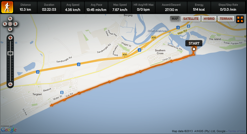
Walking east from the river mouth leads you to Reebok where you can enjoy exploring the rock pools at low tide - or if you are particularly intrepid, make a mission of it and go the full 9.6 km's to Little Brak.
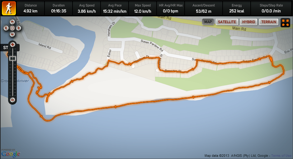
If you head west, you can walk beyond Hersham as far as Glentana - or on a low tide, to the remains of the wreck a few kilometers beyond to see what's left of a dock that was being towed from England to Durban that broke free and washed ashore during a storm in 1902. Along the way you'll pass Oystercatchers lunching on mussels in the rocks. If you don't wish to walk that far, there are plenty of opportunities to take stairs (typically steep!) up to Hersham, Outeniquastrand or Glentana. You can even wind yourself back down to the bank opposite The Island via the 130+-year-old Vishoek (Fish Hook) trail which has recently been renewed thanks to the Oyster Bay Reserve Conservation Trust and its volunteers. The trailhead - or endpoint, depending upon which direction you start from - is where Hersham Drive joins Susan Pardew Road, but you can also join it midway from Esher Crescent.
Tip: Don't forget to look out to sea occasionally when on your beach walk or you'll miss the dolphins!
Walking east from the river mouth leads you to Reebok where you can enjoy exploring the rock pools at low tide - or if you are particularly intrepid, make a mission of it and go the full 9.6 km's to Little Brak.
If you head west, you can walk beyond Hersham as far as Glentana - or on a low tide, to the remains of the wreck a few kilometers beyond to see what's left of a dock that was being towed from England to Durban that broke free and washed ashore during a storm in 1902. Along the way you'll pass Oystercatchers lunching on mussels in the rocks. If you don't wish to walk that far, there are plenty of opportunities to take stairs (typically steep!) up to Hersham, Outeniquastrand or Glentana. You can even wind yourself back down to the bank opposite The Island via the 130+-year-old Vishoek (Fish Hook) trail which has recently been renewed thanks to the Oyster Bay Reserve Conservation Trust and its volunteers. The trailhead - or endpoint, depending upon which direction you start from - is where Hersham Drive joins Susan Pardew Road, but you can also join it midway from Esher Crescent.
Tip: Don't forget to look out to sea occasionally when on your beach walk or you'll miss the dolphins!
Beach walk from The Island, out to the rock pools at Tergniet and back
Beach walk from The Island along to Hersham and back along the Vishoek trail